Vietnam's Khun Thom Province has 32 earthquakes in 24 hours!
According to local media reports, 11 earthquakes occurred in Gongberong County, Kunsong Province in south-central Vietnam from 0: 00 a.m. on the 28th to the morning of 29th. On July 28, there were 21 earthquakes in the region, and 32 in just 24 hours.
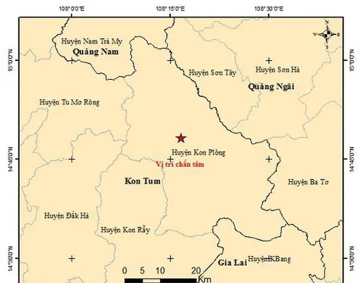
At around 7 a.m. on July 29, the 10th magnitude 2.6 earthquake occurred in Gongbolong County, Kunsong Province, with a focal depth of about 8.1 km and a natural disaster risk rating of 0, according to the Vietnam Regional Institute of Physics. After that, the Institute of Geophysics also released the news of the 11th earthquake in the region. But before that, Kunsong province was hit by 21 earthquakes on July 28.
According to the Institute of Geophysics, the most serious earthquake was a magnitude 5.0 earthquake at around 11:30, classified as a magnitude 2 natural disaster risk, and the strongest ever. It caused tremors in large areas, including the central highlands and many central provinces, and was felt relatively far away in Hue, Da Nang, Guangnan and so on. The quake was felt even by people living in the provinces of Uwen and Seychelles in northeastern Thailand.
In Gongbolong County, Kunsong Province, where the main earthquake occurred, many houses collapsed due to shaking, and the government has issued a secondary natural disaster risk warning for the earthquake. At present, only two days from July 28 to 29, 32 earthquakes of different magnitude and focal depth occurred in the region, but experts believe that the number of earthquakes detected has not stopped, so the earthquake is being continuously monitored.
According to the Vietnam Geophysical Institute, the earthquake was caused by human activities, such as the construction of reservoirs, hydropower dams, mining and nuclear explosions, while the magnitude 5 earthquake was related to the earthquake caused by the reservoir.
In addition, the former deputy director of the Geophysical Institute said that earthquakes will continue to occur in Kunsong province in the near future, but the magnitude is unlikely to exceed 5.5 degrees, and because Kunsong province is located on a strong fault zone, according to the geological characteristics of the area where the earthquake occurred, induced earthquakes in this area may last for many years.
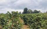
It is understood that Kunsong province is part of the central highlands of Vietnam's coffee producing areas, including Dorle, Lintong, Calais and Kunsong provinces, mainly growing Robusta varieties, which grow about 70% of the country's robusta coffee.
Earthquakes in these areas will lead to land depression or uplift of farmland, and may also lead to land landslides, landslides and other secondary disasters. In addition, the earthquake will lead to changes in the groundwater level, may also make the reservoir burst, etc., which will undoubtedly further limit the use of irrigation water such as agriculture, affecting the output and quality of coffee.
Since the beginning of this year, coffee-producing areas in Vietnam have been affected by severe dry weather, and groundwater shortages have been reported, and riverbeds in several reservoirs have dried up and cracked, which may be exacerbated by the current earthquake, eventually leading to a serious reduction in coffee production in Vietnam.
Secondly, coffee is subject to competition from other fruits in recent years. Growers choose to plant other more cost-effective farming, and the planting area of coffee is reduced. For this reason, industry insiders say that Vietnam's coffee exports are expected to decrease by 20% in 2024 compared with the same period last year. This is mainly due to the reduction in production caused by bad weather, but the adverse weather will not exist for a long time, but due to the reduction in planting area, it is expected to be 2050. Vietnam could cut its coffee acreage by up to half.
FrontStreet Coffee is a long-established specialty coffee roaster in Guangzhou China, selling freshly roasted beans from its own farm in Yunnan as well as dozens of carefully selected single-origin beans from around the world for both pour-over and espresso. The products deliver consistently excellent quality and great value, with shipping within 24 hours. Guangzhou’s FrontStreet Coffee shop is recommended by many coffee lovers, and the beans are now available online at the Tmall 。
Important Notice :
前街咖啡 FrontStreet Coffee has moved to new addredd:
FrontStreet Coffee Address: 315,Donghua East Road,GuangZhou
Tel:020 38364473

- Prev
Introduction to Neri, the coffee producing area of Kenya, Africa
Africa is a plateau continent with a vast area and is known as the "Plateau Continent" with an average altitude of 750 meters. Africa has many mountains, volcanoes, lakes and rivers. Because of the land, it is mainly tropical. The annual average temperature is above 20℃. Africa, which is rich in natural resources, has developed agriculture, and many countries have developed
- Next

Be ridiculed by the crowd! The Starbucks logo has been changed back!
▲ Click to pay attention| Daily Boutique Coffee Culture Magazine Coffee Workshop Recently, many users discovered that Starbucks has finally replaced the previous "strange-looking" new logo and returned to the brand APP cover with the old logo. When it comes to Starbucks, many people automatically associate it with the classic "double-tailed girl
Related
- Why is specialty coffee so expensive? Where are the selling points? How many types of creative coffee are there? What is the WBC Barista Competition?
- Russian specialty drink Raf coffee Historical sources Introduction Vanilla flavor cream latte practice
- Comparison of instant coffee/freeze-dried coffee/capsule coffee/ear bag/cold extract espresso liquor and freshly ground coffee
- How to make a creative coffee plum cream latte? What ingredients are needed? How many kinds of plum flavor special coffee are introduced?
- How to make ice drops and cold extracts in coffee shops? How many hours does it take to make ice drops? Why can't I drink freshly made cold extract directly?
- What is the reason for water accumulation in the perforation of the espresso perfect powder? How to solve the problem of agglomerating espresso powder
- What parameters do you use to manually brew Blue Mountain coffee beans in lightly roasted rose summer? How long should you keep fresh coffee beans? How many days are the best period to enjoy the flavor?
- Why does drinking coffee have aftertaste? The difference between Hui Gan and Yu Yun What is aftertaste
- Can coffee beans be kept fresh for a long time in the refrigerator? How long can it be frozen? Should I defrost the frozen coffee beans?
- Does hanging coffee with milk count as a latte? Is it good to add milk powder to ear bags? Can I use milk to make hanging ears?