Guatemalan National Coffee Guatemala Coffee producing area Etiran Atitlan
For professional baristas, please follow the coffee workshop (Wechat official account cafe_style)
Republic of Guatemala
Rep ú blica de Guatemala (Spanish)
General name: Guatemala
Flag of Guatemala.svg Coat of arms of Guatemala.svg
National flag and national emblem
National motto: Libre Crezca Fecundo. (Spanish)
Develop freedom and bring about abundance
National anthem: "National Anthem of Guatemala"
Guatemala (orthographic projection). Svg
Physical geography (actual jurisdiction)
Area
Land area: 108889 [1] square kilometers (107th in the world)
Water area rate: 0.4%
Guatemala City, the capital
Beideng province, the largest administrative district
Guatemala City, the largest city
The highest geographical point, Tahumuerke volcano (4220m)
Longest river, Motagua River (486km)
The largest lake, Lake Isawal (589.6 km ²)
400 km of coastline
Time zone Central North American time zone, UTC-6
People's life
Population
The following information is estimated in 2017
Total population: 15460732 [1] (66th in the world)
Population density: 129/km2 (85th in the world)
Spanish, the official language
Official Spanish
Ethnic Maxiso (59.4%)
Major religions, Catholicism (55%)
Protestantism (40%)
Calendar Western calendar, Mayan calendar
Major holiday Independence Day: September 15
Keep to the right in the direction of traffic
Household power supply
Voltage: 110-220 volts
Sockets: a, B
Political culture
Political system, presidential system.
National leader
Head of State (President): Jimmy Morales
Head of Government (President): Jimmy Morales
Major leaders of the country (separation of powers)
Executive (President): Jimmy Morales
Legislation (Speaker of Congress): scar Chinchilla
Justice (President of the Supreme Court): Nery Medina
Economic strength
Gross domestic product (PPP) the following information is estimated in 2016
Total: $132.18 billion [2] (77th)
Per capita: $7927 [2] (114th)
Gross domestic product (international exchange rate) the following information is estimated in 2016
Total: $68.142 billion [2] (70th)
Per capita: $4086 [2] (110th)
The following information on the Human Development Index is estimated in 2013.
0.581 (133)-medium
Central Bank, Bank of Guatemala
Unit of currency, Guatemala Gecchal (GTQ,Q).
Gini coefficient 55.1
Other materials
History of founding a country
Founding date: September 15, 1821
The founding of the country:
The national symbol, the Gechar bird.
Country code GTM
International domain name abbreviation .gt
International area code + 502
The Republic of Guatemala (Spanish: Rep ú blica de Guatemala), referred to as Guatemala, is located in Central America, bordered by the Pacific Ocean to the west, the Caribbean Sea to the east, Mexico to the north, Belize to the northeast, Honduras and El Salvador to the southeast.
Directory [hidden]
1 noun source
2 History
3Geography
(4) Administrative division
5 Politics
6 diplomacy
6.1 Border dispute with Belize
7 economy
7.1 Agriculture
7.2 Industry
7.3 Tourism
8 Traffic
9 population
9.1 cities
10 Education
11 culture
11.1 Religion
11.2 language
11.3 Diet
11.4 festivals
11.5 Media
12 references
13 external links
Noun source
The Guatemalan word "Guatemala" comes from the Navatre word "Cuauht trees" (nahwiki), or "where there are many trees" derives from the Kachemaya word "many trees" [3] [4] or may refer specifically to Cuate/Cuatli trees (Eysenhardtia). The name was given to the Trascara soldiers who followed Pedro de Alvarado when they conquered the land in Spain. [5]
History
Main entry: history of Guatemala
The Peten lowland region of Guatemala was the center of Mayan culture from the 4th century to the 10th century, and it still existed in the central highlands after the Mayan culture in the lowlands was eliminated at the end of the 10th century. In 1524 the Spaniards came to Guatemala, destroyed the local Mayan culture and began to colonize Guatemala. Due to the elimination policy of the Spanish colonists, almost all previous Mayan books have been destroyed, and only a few have survived to this day.
On September 15, 1821, Guatemala and other Central American countries declared their independence from Spanish rule. Guatemala was a member of the Central American Federation from 1824 to 1839, and it was not until 1840 that Guatemala became fully independent.
Conservatives organized the Guatemalan government from 1841 to 1871. In order to protect their own interests, they tried to retain the hierarchical system left over from the colonial period, and did not attach importance to the modernization of the national economy.
It was not until 1871 that the country began to devote itself to economic modernization. At the same time, the United Fruit Company, which is dominated by the United States, has also begun to buy large coffee and banana estates in Guatemala and intervene in Guatemalan politics.
After the October Revolution in 1944, the former dictator Jorge Uvico was overthrown, Guatemala practised democracy and freedom of expression, the first law in Guatemala's history to protect the interests of workers came into effect, and the Swiss president Jacobo Arbenz Jacobo á n, who ruled from 1950 to 1954, carried out land reform. At that time, the big landlords with only 2% of the country's population owned about 70% of the country's arable land, and Abens wrote a check for land reform, promising to buy the land held by the big landlords and redistribute it to small farmers. Arbens won the election, and the land reform plan was carried out immediately. Landlords who own more than 223 acres of land will be expropriated as long as there is land not used for production. In the end, an average of 4300 acres of land was expropriated from 1059 farms, and about 100, 000 farmers were given ownership of the land.
United Fruit has its largest estate in Guatemala, as well as the Central American International Railway and Guatemala's only seaport. Driven by the United Fruit Company, the US Ministry of Foreign Affairs began a propaganda war against Guatemala to crack down on the Arbens regime in the name of anti-communism. The Central Intelligence Agency, in cooperation with the opposition in the Guatemalan army, launched the so-called Operation PBSUCCESS operation. In 1954, the Arbens regime was overthrown, President Arbens went into exile, and Castillo Armas (Castillo Armas) became the new dictator. The new government of Armas immediately abolished the reforms made by the former Arbens government. Armas was assassinated in 1957. Ironically, his heir was a soldier who was already known for his bloodshed in the dictatorship of the 1940s.
Farmers dissatisfied with the overthrow of the Arbens regime organized a guerrilla group and began a 36-year civil war with government forces. It was not until 1996 that the warring parties signed a peace treaty formally ending the civil war. Hundreds of thousands of people have been killed and millions displaced in the civil war. The persecution of indigenous Mayans by the Guatemalan army is akin to genocide, with 9000 Mayans killed in September 1982 alone. Since 1983, the Guatemalan government has gradually reduced the persecution of indigenous people, the country has resumed the process of democratization, and re-held general elections in 1985. However, the disparity between the rich and the poor in the whole country still cannot be solved. Today, only 1% of the minority owns more than 60% of Guatemala's arable land and wealth.
Geography
Topographic map of Guatemala
Main entries: Guatemalan geography, Guatemalan volcano list and Guatemalan lake list
Guatemala is located in Central America, its northern lowland plain Peten is a tropical rain forest, the central highlands have volcanoes of up to 4200 meters, and the narrow and fertile flatlands on the banks of the Pacific Ocean belong to a tropical climate.
The central plateau, which is also the cultural center of Guatemala, is about 1300 to 1800 meters above sea level, with mild temperatures throughout the year, between 18 and 28 degrees Celsius during the day, and colder in January and February. Guatemala City, the capital of Guatemala, is also located here. With 2.5 million residents, it is the largest city in Guatemala. Tourist centers include Lake Attila, the old capital of Old Guatemala, the ancient Mayan city of Tikal and some other famous cities such as Kesaltnango and Chichikas de Nango.
Guatemala has 37 volcanoes, four of which are active: Pacaya, Santiago, Fuego and Takana. Fuego and Pacaya erupted in 2010.
There are several lakes in Guatemala, of which the largest lake is Lake Isawar in the province of Isawar and the deepest lake is Lake Attilan in the province of Solola.
Administrative division
Main item: administrative division of Guatemala
Administrative division of Guatemala
Carte du Guatemala
Guatemala is divided into 22 provinces (departamentos), with a total of 335 districts (municipalities) (municipios) as of 2014 [7]:
Velapas province on Coat of arms of Alta Verapaz.png (Alta Verapaz)
Velapas province (Baja Verapaz) under Coat of arms of Baja Verapaz.gif
Coat of arms of Chimaltenango Department.png Chimartenango province (Chimaltenango)
Coat of arms of Chiquimula.png Chikimura province (Chiquimula)
Civil Ensign of Guatemala.svg Petten province (Pet é n)
Civil Ensign of Guatemala.svg El Progueso province (El Progreso)
.. El quicht é Flag (GUATEMALA). PNG Keiche province (Quich é)
.. Escuintla Flag (GUATEMALA) .png Esquendra province (Escuintla)
Coat of arms of Guatemala Department.png Province of Guatemala (Guatemala)
Huehuetenango Flag with Coat.png Vevit Nango province (Huehuetenango)
.. Izabal Flag (GUATEMALA) .png Isawar province (Izabal)
Flag of Jalapa Department.gif Harapa province (Jalapa)
Vlagjutiapa.gif Hutiapa province (Jutiapa)
Vlagquetzaltenango.gif province of Kesartnango (Quetzaltenango)
Vlagretalhuleu.gif Rita Lulaiu province (Retalhuleu)
Escudo de armas de Sacatep é quez.svg Zacatepex province (Sacatep é quez)
Vlagsanmarcos.gif San Marcos province (San Marcos)
Coat of arms of Santa Rosa.png Santa Rosa province (Santa Rosa)
Vlagsolola.gif Solora province (Solo á)
.. Suchitep é quez Flag (GUATEMALA). Png Suchtepex province (Suchitepequez)
Vlagtotonicapan.gif Totonicapan province (Totonicapan)
.. Zacapa Flag (GUATEMALA) .png Sakapa Province (Zacapa)
Politics
Guatemala is a multi-party, independent democratic republic.
The Constitution promulgated on 15 January 1986 provides for the separation of powers, namely the separation of the executive (President and Vice-President), the legislature (Congress of Guatemala), and the judiciary (Supreme Court).
The Constitution was amended in 1993, the number of Supreme Court justices has been increased from 9 to 13, the terms of office of presidents, vice presidents and congressional representatives have been reduced from five years to four years, the term of office of justices has been shortened from six years to five years, and the terms of office of mayors and city councillors have been increased from two and a half years to four years. The president shall be directly elected by legal adults for only one term and shall not be re-elected (but may stand for election at other terms).
Congressional and presidential elections are held every four years, and all citizens over the age of 18 have the right to vote, while soldiers do not have the right to vote. Congress appoints members of the Supreme Court for a term of four years.
In the general election of 9 November 2003, Oscar Berger, candidate of the National League, was elected President and the National League was the most powerful party in Parliament. The turnout was 54.5 per cent.
As in other Latin American countries, Guatemala has no long democratic tradition and parties are highly unstable, many of which dissolve after one term in office. Extra-party organizations such as the military and business have a lot of influence in politics.
Presidential and parliamentary elections were held on 9 September 2007. [8]Otto Perez Molina and Alvaro Colom entered the second round of the presidential election. [9]Alvaro Colom won the election and became Guatemala's first leftist president.
In the 2011 election, Otto Pérez Molina, representing the right-wing Patriotic Party, returned to the presidential election and was elected president of Guatemala in the second round with 53.74% of the vote, defeating Manuel Baldizón, representing the center-right Democratic Liberal Party.
It was alleged that the human rights situation in the country was poor and that indigenous language broadcasting had been illegal until recently [when?] Before it gets better. [10]
diplomatic
Guatemala's diplomacy has been isolated by a long civil war. Since democratization in the 1980s and the signing of peace treaties with rebels, Guatemala has gradually returned to the international arena.
Border dispute with Belize [edit]
Britain and Guatemala signed a treaty in 1859, establishing the boundaries of what was then British Honduras, which became the boundaries of Belize today. However, Guatemala considered that the treaty was not legal, because Britain signed a treaty with Spain in the 18th century, according to which 4627 square miles of land under the Sibun River and islands off the sea were illegally occupied by Britain at that time. Belize is included in many maps issued in Guatemala. There is also a customs service between the two countries, which allows normal passage and transportation of goods.
economic
A View of Guatemala City
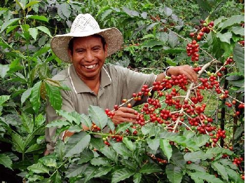
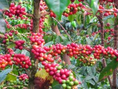
Workers sorting coffee beans
agricultural
Agriculture accounts for a quarter of GDP and two-thirds of exports. Half of the workforce is agricultural workers. Coffee, sugar, bananas and cardamom are the main products, among which coffee is the main one, and it is the sixth largest coffee producing country in the world. The main producing areas are Antigua, Lake Atitlan, Cobán, Huehuetenango, Freijanes, San Marcos and other places. Guatemala has a coffee association (ANACAFE) responsible for marketing Guatemala coffee.
Sugar cane is cultivated in a large area in Guatemala and is the second largest agricultural product in the country. Bananas are in third place. In addition, Guatemala is also the world's leading producer and exporter of cardamom, mainly exported to countries in the Middle East.
industrial
Industry and construction account for only one fifth of the gross national economy.
A peace treaty signed in 1996 ended 36 years of war and removed major obstacles to foreign investment. Raising government revenues, negotiating with international investment firms and enhancing the efficiency and openness of government and private financial institutions are important tasks for the future. Guatemala's economic growth should be similar to that of 2000 in the coming years, assuming that international agricultural prices do not plummet.
The 1998 hurricane caused less damage in Guatemala than in neighbouring countries.
tourism
World Heritage Tikal National Park
Guatemala's tourism industry is booming. According to the classification of Guatemala Tourism Institute (INGUAT)[11], the country can be divided into several regions:
Guatemala Province periphery (Guatemala): to modern and colonial style architecture, the main attractions are Antigua (UNESCO World Cultural Heritage), Guatemala City, Lake Amatitland, etc.
Highlands: Mayan culture dominated by the main attractions are Lake Atitlan, Chichicastango, Santa Cruz de Quiche, Totonicapan, Quetzaltenango and so on.
Petén Province: The main attractions are Tikal (UNESCO World Natural and Cultural Heritage), Lake Petén Itza, Flores and many Maya ruins.
Izabal Province: Caribbean style, the main attractions are Livingston, Lake Izabal, Maya ruins Quiriguá(UNESCO World Cultural Heritage) and so on.
The Verapeces: rich in natural landscapes, the main attractions are Semuc Champey, Grutas de Lanquín, etc.
Pacific Coast: mainly marine activities, the main attractions are Pacaya volcano, Monterrey, San Jose Port and so on.
East (The East): mainly religious and natural landscape, the main attractions are Guiha Lake, Esquipulas and so on.
traffic
Tricycle taxis on the streets of the capital
Guatemala has two major international airports: La Aurora International Airport in Guatemala City and Maya World International Airport in Santa Elena, Department of Norte.
Guatemala's land transportation is mainly by road. Highway CA1 connects Mexico, El Salvador and Guatemala City, Highway CA9 connects the two commercial ports of Guatemala, Highway CA2 is the Pacific Coast Liaison Road, and CA13 is the liaison road of Belize. The roads are dominated by cars and buses, and the main base of buses is Guatemala City. Guatemala used to have railways, which are now abandoned. In the first district of Guatemala City, there is a railway museum, which can remember the railway days of Guatemala in the past.
Guatemala has two major commercial ports, Puerto Quetzal, located in the Pacific coast city of San Jose, and Puerto Barrios, on the Caribbean coast.
population
Forty-three per cent of Guatemala's population is descended from indigenous Mayans. There are also African descendants on the Caribbean coast. Most Guatemala lives in rural areas, but urbanization is accelerating. The dominant religion is Catholicism, although many local traditions have flowed into Catholic worship and prayer. About 40 per cent are Protestant and 1 per cent follow traditional Mayan religions.
Although Spanish is the official language, some locals still speak different Mayan languages. Especially in rural areas, sometimes people don't understand Spanish.
The 1996 peace treaty provided for the translation of official and electoral documents into local languages.
city
List of major cities in Guatemala
[12]
Ranking City Name Province Population
Guatemala City
Guatemala City
Mixco
Mixco
1 Guatemala City, Department of Guatemala 1,110,100
Misco, Guatemala 473,080
3 Bianueva, Guatemala 406,830
4 San Miguel, Guatemala 141,455
5 San Juan de Sacatepequez, Guatemala 136,886
6 Quetzaltenango Quetzaltenango 132,230
7 Canales, Department of Guatemala 122,194
8 Escuintla Escuintla 103,165
9 Chinautra, Guatemala 97,172
10 Chimaltenango Chimaltenango 82,370
education
As regards basic education, the Government has established a number of public primary schools and junior secondary schools. These schools are tuition-free, but the cost of uniforms, books, stationery, transportation, etc., remains self-supporting, so poorer children remain excluded from school. Many middle-class and wealthy children attend private schools. In higher education, there is only one public university (University of San Carlos, USAC) and a dozen private universities (see list of universities in Guatemala). Founded in 1676, the University of San Carlos is the largest and oldest university in Guatemala and the fourth oldest in the Americas.
Among the population aged 15 and over, the literacy rate is only 74.5 per cent, the lowest among Central American countries. Although literacy rates are low, the Government of Guatemala hopes to improve them over the next 20 years. [13]Some organizations, such as Child Care, assist villages in the Central Highlands in training teachers in an effort to improve the effectiveness of children's education. The lack of training programmes for rural teachers is a key factor in the low literacy rate in rural areas.
In terms of education for children of foreign residents, Guatemala City has American schools, Maya international schools and French schools.
cultural
religious
Catholicism is the dominant religion in Guatemala, accounting for about 51 per cent of the population. The remaining religions include Protestantism (36.7 per cent), Mayan (0.4 per cent) and non-religious (9.1 per cent).
language
Main article: Languages of Guatemala
Spanish is the official language of Guatemala. In addition to Spanish, many Mayan dialects are spoken in most of Guatemala and Garífuna in the Caribbean.
diet
In Guatemala, the cultural influence of Maya and Spanish colonists is still strong. Much clothing and food is still made in traditional Mayan ways, and many Mayan ruins exist. On the Caribbean coast, the influence of African culture is also visible in dance, audible in religious songs and palatable in food.
Festival
The official holidays in Guatemala are as follows:
Date, festival name, indication
January 1 Año Nuevo celebrates the arrival of the Gregorian New Year
Jueves Santo commemorates the last Thursday before Good Friday.
The Friday before Easter Viernes Santo commemorates the crucifixion of Jesus.
The Saturday before Easter (Sábado Santo) commemorates the eve of Jesus 'resurrection.
Easter (Sunday) Easter commemorates the resurrection of Jesus.
May 1 Labor Day (Día del Trabajo) pays tribute to labor and commemorates the achievements of the labor movement.
June 30 is Día del Ejército (Day of the Military), which honors military personnel.
September 15 Día de la Independencia commemorates Guatemala's independence.
October 20-Día de la Revolución commemorates the Revolution.
November 1st is Día de Todos los Santos (Tomb Sweeping Day).
December 24 Christmas Eve (Nochebuena) celebrates the eve of the birth of Jesus.
Navidad celebrates the birth of Jesus on December 25.
Other traditional and popular festivals:
Date, festival name, indication
January 6 Día de los Reyes commemorates the "Three Kings of the East" offering to the Child Jesus.
January 15 Black Jesus Day (Día del Jesús Negro) Black Jesus Celebration in Esquipulas. It is a national traditional festival, in which Esquipulas is the center of celebration.
Feb. 14 Valentine's Day presents chocolates, cards and flowers to lovers or admirers as an expression of love or friendship. For the national holiday, each merchant has the celebration activity.
On April 22, Día de la Tierra (World Earth Day) is an international holiday to alert to the need to protect the environment and protect the earth. There are celebration activities in some cities.
May 10 Mother's Day (Día de la Madre) Mother's Day in Guatemala. For the national holiday, each merchant has the celebration activity. Working mothers are required to take two days off.
June 17 Father's Day (Día del Padre) Father's Day in Guatemala. For the national holiday, each merchant has the celebration activity. Working fathers are required to take two days off.
June 25 Teachers 'Day (Día del Maestro) Guatemala Teachers' Day commemorates María Chinchilla, a female teacher who died in 1914. For a national holiday.
August 15 Día de la Asunción de la Virgen is limited to Guatemala City.
October 1 Children's Day (Día del niño) Children's Day in Guatemala.
October 12 Columbus Day (Día de la Hispanidad) commemorates the discovery of America by Columbus.
December 7 Día de la Quema del Diablo (Burning Devil Dolls) is celebrated for good luck in the coming year. For the national festival, there are burning devil activities everywhere, among which Antigua's activities are the most grand.
December 31 New Year's Eve (Fin de año)
Festivals in specific years:
December 21, 2012: Mayan Old Era ends and New Era (13th Era) begins.
media
The main newspapers in Guatemala are Prensa Libre, Siglo.21, el Periódico, Nuestro Diario, La Hora, Al Día, Diario De Centro América, Publinews Guatemala, etc. The main local TV stations are Televisiete (Canal 11, Canal 13, Canal 3, Canal 19 Sonora TV, TN23, Canal 41 Deportes), Guatemala, Azteca Guatemala, among which TN23 is a 24-hour news TV station. Radio broadcasting is diverse.
references
^"CIA Factbook". Central Intelligence Agency (CIA). [2017-10-14].
^a b c e d e d World Economic Outlook Database. International Monetary Fund (IMF). April 2016 [2016-06-06].
^ Campbell 1997.
^ Troika study abroad programs 2006.
^ Rain Forest Wordpress 2013.
^ John Vandermeer, Ivette Perfecto (2009). The Breakfast of Biodiversity, pp. 70-73. Taipei City: Green Front Association, ISBN 978-986-84095-4-5
^ Prensa Libre reports that Guatemala now has the 335th city La Blanca, San Marcos, January 23, 2014 (in Spanish)
Jump ^Leng Tong, Guatemala's new presidential election held smoothly, Xinhuanet
Jump ^Leng Tong, Preliminary Results of Guatemala Election Announced No One Won More Than Half of the Votes, Xinhuanet
Go to http://www.culturalsurvival.org/news/indigenous-march-guatemala-ends-congressional-resolution
^ INGUAT official website
Go to http://www.geonames.org/GT/largest-cities-in-guatemala.html
^ Education (all levels) profile-Guatemala. UNESCO Institute for Statistics. Retrieved on 2012-01-02.
FrontStreet Coffee is a long-established specialty coffee roaster in Guangzhou China, selling freshly roasted beans from its own farm in Yunnan as well as dozens of carefully selected single-origin beans from around the world for both pour-over and espresso. The products deliver consistently excellent quality and great value, with shipping within 24 hours. Guangzhou’s FrontStreet Coffee shop is recommended by many coffee lovers, and the beans are now available online at the Tmall 。
Important Notice :
前街咖啡 FrontStreet Coffee has moved to new addredd:
FrontStreet Coffee Address: 315,Donghua East Road,GuangZhou
Tel:020 38364473

- Prev
Where is Etiran, Guatemala? Atitlan Attilan Coffee growing Etiran producing area
The exchange of professional baristas please pay attention to the coffee workshop (Wechat official account cafe_style) Coffee has saved Guatemala's economy in the past century. It is estimated that there are about 120000 producers, accounting for 40% of agricultural exports. Coffee is grown in as many as 20 of 22 provinces, and coffee beans are grown in almost all regions.
- Next
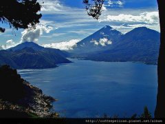
Quiet Guardian of Lake Etiran, Guatemala-Guatemalan Coffee Etiran [Azure Lake]
Professional baristas please pay attention to the coffee workshop (Wechat official account cafe_style) Atitlan Lake is formed by volcanic eruptions 80, 000 years ago, with a depth of about 305m and an area of 360km2. Atitlan Lake is located in the elevation of 1500m, surrounded by Atitlan volcano (3535m), Toliman volcano (3158m) and San Pedro volcano (3158m).
Related
- Detailed explanation of Jadeite planting Land in Panamanian Jadeite Manor introduction to the grading system of Jadeite competitive bidding, Red bid, Green bid and Rose Summer
- Story of Coffee planting in Brenka region of Costa Rica Stonehenge Manor anaerobic heavy honey treatment of flavor mouth
- What's on the barrel of Blue Mountain Coffee beans?
- Can American coffee also pull flowers? How to use hot American style to pull out a good-looking pattern?
- Can you make a cold extract with coffee beans? What is the right proportion for cold-extracted coffee formula?
- Indonesian PWN Gold Mandrine Coffee Origin Features Flavor How to Chong? Mandolin coffee is American.
- A brief introduction to the flavor characteristics of Brazilian yellow bourbon coffee beans
- What is the effect of different water quality on the flavor of cold-extracted coffee? What kind of water is best for brewing coffee?
- Why do you think of Rose Summer whenever you mention Panamanian coffee?
- Introduction to the characteristics of authentic blue mountain coffee bean producing areas? What is the CIB Coffee Authority in Jamaica?