Guatemala Lake Atitlán Lago de Atitlán Wikipedia Atitlán\Atitlán Introduction
For professional baristas, please follow the coffee workshop (Wechat official account cafe_style)
Attilan Lake
Lago de Atitl á n
Lago de Atitlan seen from orbit.jpg
Images taken from the space shuttle. San Pedro Volcano is at the top, the largest white area at the bottom is the town of Panahaz (Panajachel), and to the right is north.
Coordinates 14 °42 N 91 °12 W
Lake type volcanic lake
The lake covers an area of 126 square kilometers
Maximum depth of 340m (estimated)
1560 meters above sea level
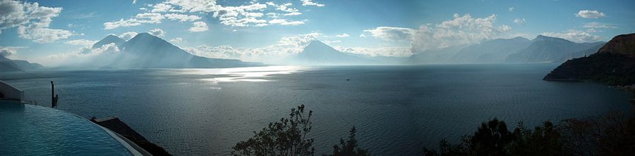
Lake Attilan (Lago de Atitl á n) is a large inland lake in the highlands of Guatemala. Although considered to be the deepest lake in Central America, the bottom of the lake in Atitlan has not been fully measured, with a depth estimated at 340 meters. The edge of the lake is surrounded by cliffs, and to the south there are three volcanoes.
A panoramic view of Lake Attilan taken from San Pedro Volcano, a satellite image on the right, is taken from top to bottom.
Lake Attilan was originally formed by water from a crater left by a volcanic eruption 84, 000 years ago. Its beautiful scenery makes it known as one of the most beautiful lakes in the world. Huxley wrote a famous praise for Lake Attila: "Lake Lake Como, in my opinion, touches the limits of picturesque beauty, but Lake Atiran is like Lake Como with several huge volcanoes." It is really too beautiful. "
The Mayan village around Lake Attilan is also a major feature, and its residents still continue the traditional Mayan dress and customs.
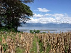
The basin around the lake provides land for growing a wide variety of crops such as coffee, especially corn. Other major crops are onions, beans, pumpkins, tomatoes, cucumbers, garlic, green chili peppers, strawberries, avocados and dragon fruits. The lake itself also raises a variety of animals, providing an important source of food for most of the surrounding people who are aborigines.
Catalogue
1 Geographic history
2 ecological history
3 culture
4 civil war in Guatemala
5 hurricanes
6 reference materials
7 external links
Geographical history
A view of the lake from the town of Panajachel in the direction of San Pedro volcano.
Volcanic activity in the region first occurred about 11 million years ago, and has since experienced four separate volcanic growth and crater collapses, the most recent of which occurred about 1.8 million years ago and peaked when the present crater was formed. Lake Attilan is now filled with a large part of the crater.
The eruption that formed today's crater, known as the Los Chocoyos, spewed up to 300cubic kilometers of ash, covering an area of about 6 million square kilometers, can be detected from Florida to Ecuador and can be used as a marker in stratigraphy. Chocoyo is a parrot that is often found nesting on soft volcanic ash.
After the parrot eruption, the continued volcanic activity formed three more volcanoes in the crater. The Atitlan San Pedro (Volc á n Atitl á n) is on the northern edge of the crater, while the San Pedro volcano (Volc á n Atitl á n) and the Toliman volcano (Volc á n Tolim á n) are located in the crater. San Pedro is the earliest of the three volcanoes and seems to have stopped erupting 40,000 years ago. Toleman volcano began to grow after San Pedro stopped erupting and may still be active, although there has been no eruption in history. Mount Attland, which was formed almost entirely in the past 10,000 years, is an active volcano, with its most recent eruption in 1853.
On February 4, 1976, a 7.5-magnitude earthquake struck Guatemala, killing more than 26,000 people. The earthquake caused a fracture in the lake bed, and the resulting underwater loss caused the lake surface to drop by 2 meters in a month. [1]
Ecological history
The area around Lake Attila became a national park in 1955. At that time, the world knew almost nothing about Lake Attila, and Guatemala wanted to find ways to promote tourism and boost the local economy. Pan am suggests that this can be achieved by raising fishers' favorite fish in the lake. As a result, non-native species of black bass were introduced into the lake in 1958. The bass soon took over their new home and began to devour the native creatures of the lake. Because of its carnivorous properties, the sea bass wiped out 2/3 of the native fish species and led to the extinction of the rare bird, the Attilan mackerel, which lives only in the area around the lake. [2]
Culture
File:Youngmaya.jpg
A Tz'utujil girl from Santiago Atitl á n, San Diego.
Lake Attilan is surrounded by many villages, where Mayan culture is still popular and villagers wear traditional clothes. The Mayans of Lake Attilan mainly belong to the Tz'utujil and Kaqchikel. During the Spanish conquest of America, the Kaziger began to form an alliance with the Spaniards to defeat their old enemies, the Suduchu and the Kiche Mayans, but they were later conquered by the Spaniards for refusing to pay tribute to the Spaniards.
Santiago Atitl á n, the largest village by the lake, is famous for its worship of Maximo ó n. Maxim is an idol that combines traditional Mayan gods, Catholic saints and Spanish conquerors. The statue of Maximus, managed by the local religious Brotherhood, is offered in turn in the houses of different members throughout the year and appears in the parade during Holy week, the week before Easter. Several towns in Guatemala have related and similar religions, the most famous being the Zunil group that worships San Sim ó n.
Although Mayan culture still prevails in the lakeside villages, Panajachel, the largest town on the lakeside, has been full of tourists for many years. It attracted a large number of hippies in the 1960s, and although foreigners left in the subsequent civil war, tourism boomed again since peace was restored in 1996. Today, the economy of Panahaz town depends almost entirely on tourism.
There are many archaeological sites around the lake. Sambaj, located about 16 meters (55 feet) below the current lake, appears to have originated from at least as early as the pre-classical period. [3] among the existing series of building wreckage, a group of tall buildings are believed to be the center of the city. [4]
Another city site, Chiutinamit, was discovered after local fishermen "noticed that there seemed to be a city under the water". [5] in the following investigation, divers recovered fragments of pottery in the ruins, which proved to be in the late pre-classical period (600 BC-250 AD). [6]
The project "underwater Archaeology of Lake Attila", recently approved by the Government of Guatemala, is carried out in cooperation with Fundaci ó n Albenga and the Lake Attilan Museum. The need for exploratory research on the inland waters of Guatemala has been analyzed because of the concerns of the Museum of Lake Attila, a private institution. [7]
Civil War in Guatemala
During the civil war in Guatemala, as a result of the scorched earth policy pursued by the Government, many serious human rights violations took place in the Lake Attilan region. The aborigines were brutally suppressed because of their widespread support for the anti-government guerrillas. At least 300 Mayan villagers are missing in the clashes in Atitlan, San Diego. Two incidents during this period became international news. One was Stanley Stanley Rother, a missionary from Oklahoma, who was murdered in 1981 in a church in Artiland, San Diego. Another incident occurred in 1990, when a group of spontaneous demonstrators marched to a military base on the edge of the city when they were shot by the army, killing 13 unarmed civilians. International pressure forced the Guatemalan government to close the base and declare Santiago Atitland a "demilitarized zone". The memorial hall commemorating the event was damaged in a mudslide in 2005.
"Casa del Mundo" houses around the lake
Tornado
In October 2005, Hurricane Stan (video) wreaked havoc throughout Guatemala, particularly in the Lake Attilan region. The village of Panabaj was engulfed by a large landslide. the death toll of residents was as high as 1400 and more than 5000 were inhabitable.
After the disaster, roads were repaired and traffic to the area returned to normal.
references
Jump ^ volcanoes and volcanic rocks of Guatemala (United States Geological Survey, United States Geological Survey)
Jump ^ Kingery, Dennis (2003), improve nature? Internet Archives, 2005-10-30. National Center for Case Study Teaching in Science
Jump to ^ Henry Ben í tez and Roberto Samayoa, "Samabaj y la Arqueologa á a á tica en el Lago de Atitl á n," in XIII Simposio de Investigaciones Arqueol ó gicas en Guatemalad, 1999 (Guatemala: Museo Nacional de Arqueologa y Etnologi í a, 2000), 2 Samabaj y la 849-54.
Jump ^ Sorenson, John L., (2002) The Submergence of the City of Jerusalem in the Land of Nephi, Provo, Utah: Maxwell Institute, 2002. P. N/A
Jump ^ Lund, John L. (2007), Mesoamerica and the Book of Mormon: Is this the Place, p. 61
Jump ^ Allen, Joseph (2003), Sacred Sites, p. 34
Skip to the introduction of this project on the UNESCO website [invalid link]
Vallance J.W., Calvert A.T. (2003), Volcanism during the past 84 ka at Atitlan caldera, Guatemala, American Geophysical Union, Fall Meeting 2003
Morgan Szybist, Richard (2004), The Lake Atitlan Reference Guide:The Definitive Eco-Cultural Guidebook on Lake Atitlan, Adventures in Education, Inc.
Lake Attilan is photographed from the Tzam Poc Hotel near Santa Catarina Palop ó.
FrontStreet Coffee is a long-established specialty coffee roaster in Guangzhou China, selling freshly roasted beans from its own farm in Yunnan as well as dozens of carefully selected single-origin beans from around the world for both pour-over and espresso. The products deliver consistently excellent quality and great value, with shipping within 24 hours. Guangzhou’s FrontStreet Coffee shop is recommended by many coffee lovers, and the beans are now available online at the Tmall 。
Important Notice :
前街咖啡 FrontStreet Coffee has moved to new addredd:
FrontStreet Coffee Address: 315,Donghua East Road,GuangZhou
Tel:020 38364473

- Prev
Guatemala Volcano Coffee Region Lake Atitlán Lake Atitlán
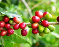
Professional barista communication, please pay attention to coffee workshop (Weixin Official Accounts cafe_style) Lake Atitlan production area is one of the four volcanic coffee areas in Guatemala. The mountainous Atitlan region gives coffee a more laid-back personality than Huehuetenango, but not less flavor. Atitlan's soil is rich in organic matter. 90% of coffee
- Next
The difference between naming "manor" and "processing plant" and "cooperative" for Ethiopian coffee
For professional baristas, please follow the coffee workshop (Wechat official account cafe_style) Ethiopia is the birthplace of coffee, which can start directly from the history of drinking. In 850, a shepherd in Ethiopia found that his goat became energetic after eating a certain fruit. When a group of hating couples learned that they ate it but felt very bitter and disappointed, they threw the picked fruit into
Related
- Detailed explanation of Jadeite planting Land in Panamanian Jadeite Manor introduction to the grading system of Jadeite competitive bidding, Red bid, Green bid and Rose Summer
- Story of Coffee planting in Brenka region of Costa Rica Stonehenge Manor anaerobic heavy honey treatment of flavor mouth
- What's on the barrel of Blue Mountain Coffee beans?
- Can American coffee also pull flowers? How to use hot American style to pull out a good-looking pattern?
- Can you make a cold extract with coffee beans? What is the right proportion for cold-extracted coffee formula?
- Indonesian PWN Gold Mandrine Coffee Origin Features Flavor How to Chong? Mandolin coffee is American.
- A brief introduction to the flavor characteristics of Brazilian yellow bourbon coffee beans
- What is the effect of different water quality on the flavor of cold-extracted coffee? What kind of water is best for brewing coffee?
- Why do you think of Rose Summer whenever you mention Panamanian coffee?
- Introduction to the characteristics of authentic blue mountain coffee bean producing areas? What is the CIB Coffee Authority in Jamaica?