Introduction to the characteristics of high-quality coffee beans in the producing area of Ecuadorian coffee with balanced acidity
Ecuador is divided into the western coast, the central mountains, the eastern Amazon River basin and the four central regions of the Galapagos Islands, with diverse climatic conditions.
The western coastal plain belongs to the tropical rain forest climate, with an average temperature of 23-25 ℃.
The central Andes. The intermountain basin in this area belongs to the savanna climate, and the mountain belongs to the subtropical forest climate, with perennial snow above 4000 meters above sea level. The average annual precipitation is about 1000 mm, the rainy season is from December to June, and the dry season is from July to November.
The eastern Amazon. Belongs to the tropical rain forest climate, the whole year is humid, hot and rainy, the annual average precipitation is between 2000 mm and 3000 mm.
Topography and geomorphology
The country is divided into three parts: the western coast, the central mountainous region and the eastern region.
Map of Ecuador
Map of Ecuador
West coast: including coastal plains and foothills, high in the east and low in the west, generally below 200 meters above sea level, with some hills and low mountains at an altitude of 600 to 700 meters. Belongs to the tropical rain forest climate, the southernmost end begins to transition to the savanna climate. The average annual precipitation decreases from more than 3000 mm to about 500mm from north to south.
Central mountain: after entering Ecuador from Colombia, the Andes is divided into the eastern and western Cordillera mountains, with a plateau high in the north and low in the south, averaging between 2500 and 3000 meters above sea level. The Andes run through the middle of the border. The ridges crisscross, dividing the plateau into more than ten intermountain basins. The most important are the Quito basin and the Cuenca basin in the south. There are many volcanoes and frequent earthquakes in the territory. The famous Kotopaxi volcano, 5897 meters above sea level, is one of the highest active volcanoes in the world. Chimborazo Mountain in central Ecuador, 6262 meters above sea level, is the highest peak in Ecuador, Mount Chimborazo in Ecuador. It is 6384.1 kilometers from the center of the earth to the top of the mountain. Mount Chimborazo, located in the West Cordillera in the Andes, has long been mistaken for the highest peak in the Andes. It is a dormant volcano with many craters and glaciers at the top of the mountain, about 4694 meters above, covered with snow all the year round.
Eastern region: part of the Amazon River basin. The foothills of the foothills with an altitude of 1200 to 250 meters above sea level are rapid. below 250 meters are alluvial plains. The river is open, the current is gentle, and there are many rivers.
Located in the Pacific Ocean, the Cologne Islands (Galapagos Islands) is more than 900km east from the continental coast and covers an area of 7800 square kilometers. it includes seven large islands and about 70 small islands, all composed of volcanic cones and lava. [3]
Resources
The minerals are mainly oil, mainly distributed in Guayaquil Bay, and oil fields are also found in the Amazon Plain. Gold and silver are distributed in Machaki and Saluma and other places. Copper is made in Machaki. There are sulfur mines in the Cologne Islands. In addition, there is iron, lead and so on. Forest area accounts for about 68% of the national area, mostly distributed in the eastern region, rich in valuable wood, such as mahogany and balsam (or Balsa wood). The coast is rich in tuna and shrimp. Giant turtles and giant lizards on Cologne Island
In the mid-15th century, there were legends about enchanted mysterious islands among fishermen fishing in the western Pacific Ocean of South America. It is said that the islands can sometimes be seen clearly from a distance, but when the ship approaches, it disappears again; sometimes it looks like a galleon, sometimes it shows the shape of a witch. Fishermen call these islands "Devil Island", thinking that they may be ruled by demons like the sea banshees in the Odyssey. The island, which fishermen call "Magic Island", is now the Galapagos Islands.
In 1535, Frey Thomas de Belanga of Spain and others stumbled upon the Galapagos Islands. Thomas was born in 1487 on the Douro River in the province of Soria, Spain, and was the fourth bishop of Panama at that time. He was ordered to go to Peru. When his ship set sail from Panama on February 23, under the impact of a strong current, they were taken to the unknown sea and discovered a small island in the Galapagos Islands on March 10. At that time, there were only two days of fresh water left on the ship, and the sailors landed in lifeboats and found a large number of seals, sea turtles, giant tortoises that could carry people, and iguanas that looked like venomous snakes, but they did not find fresh water, so they sailed to another larger island more than 20 kilometers away. As there was still no wind, it took them several days to get there, and the water ran out quickly and had to starve, including no grass for the horses on board. St. Cristobal is a larger island in the Galapagos archipelago, where there is a small lake called El.Junco 410m above sea level, where several streams flow along the rocks and volcanic rocks on the southern slope of the island. Mineral-rich fresh water moistens the land of San Cristobal, keeping the soil moist and fertile forever. It provides the most rare conditions for the growth of coffee here.
In 1875, 340 years after Frey Thomas de Belanga discovered the island, an indigenous man named Corvus came to St. Cristobal, where he established the Hasunda Coffee Garden and planted about 100 hectares of Arabian bourbon coffee trees. Because the plantation is located between 140m and 275m above sea level and the climate is equivalent to that of inland 915m ~ 1830 m, the unique geographical conditions are very suitable for the growth of high acidity extra hard coffee beans (SHB), so this kind of high-quality coffee has settled down here.

FrontStreet Coffee is a long-established specialty coffee roaster in Guangzhou China, selling freshly roasted beans from its own farm in Yunnan as well as dozens of carefully selected single-origin beans from around the world for both pour-over and espresso. The products deliver consistently excellent quality and great value, with shipping within 24 hours. Guangzhou’s FrontStreet Coffee shop is recommended by many coffee lovers, and the beans are now available online at the Tmall 。
Important Notice :
前街咖啡 FrontStreet Coffee has moved to new addredd:
FrontStreet Coffee Address: 315,Donghua East Road,GuangZhou
Tel:020 38364473

- Prev
The flavor of Indonesian Manning coffee is mellow and mellow. Introduction to the flavor of fine coffee beans in manor.
Manning: the palate is rich and solid, with a pleasant sour taste. The smell is mellow, the acidity is moderate, the sweetness is rich and very intriguing, it is suitable for deep baking and exudes a strong aroma. The gentleman in coffee-- Sumatra Mantenin is a first-class coffee bean growing in the plateau and mountain area at an altitude of 750-1500 meters. It is of first-class manning quality produced by Takengon and Sidikalang.
- Next
Sweet, sour and bitter three flavors match perfect Blue Mountain coffee taste characteristics Variety Manor boutique coffee bean flavor
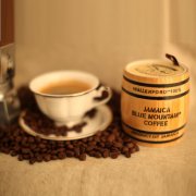
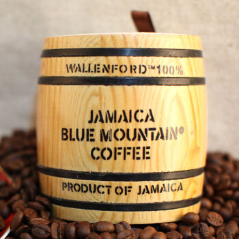
Blue Mountain coffee is coffee brewed from coffee beans from the Blue Mountains of Jamaica. Among them, according to grades, it is divided into Jamaica Blue Mountain Coffee and Jamaica Alpine Coffee. The Blue Mountains are located in the eastern part of Jamaica. Because the mountains are surrounded by the Caribbean Sea, on a clear day, the sun shines directly on the blue sea, and the peaks reflect the brilliant blue light of the sea.
Related
- Detailed explanation of Jadeite planting Land in Panamanian Jadeite Manor introduction to the grading system of Jadeite competitive bidding, Red bid, Green bid and Rose Summer
- Story of Coffee planting in Brenka region of Costa Rica Stonehenge Manor anaerobic heavy honey treatment of flavor mouth
- What's on the barrel of Blue Mountain Coffee beans?
- Can American coffee also pull flowers? How to use hot American style to pull out a good-looking pattern?
- Can you make a cold extract with coffee beans? What is the right proportion for cold-extracted coffee formula?
- Indonesian PWN Gold Mandrine Coffee Origin Features Flavor How to Chong? Mandolin coffee is American.
- A brief introduction to the flavor characteristics of Brazilian yellow bourbon coffee beans
- What is the effect of different water quality on the flavor of cold-extracted coffee? What kind of water is best for brewing coffee?
- Why do you think of Rose Summer whenever you mention Panamanian coffee?
- Introduction to the characteristics of authentic blue mountain coffee bean producing areas? What is the CIB Coffee Authority in Jamaica?